


sentier des chamois

cron
User
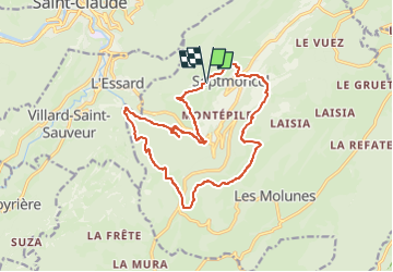

Length
16.5 km

Max alt
1212 m

Uphill gradient
1033 m
Km-Effort
30 km

Min alt
451 m

Downhill gradient
1031 m
Boucle
Yes
Creation date :
2024-03-06 10:15:14.582
Updated on :
2024-03-06 10:17:43.767
6h52
Difficulty : Very difficult

FREE GPS app for hiking
 SityTrail
IGN / Geographical institutes
SityTrail Plus
The world is yours!
About
Trail Walking of 16.5 km to be discovered at Bourgogne-Franche-Comté, Jura, Septmoncel les Molunes. This trail is proposed by cron.
Description
Départ : de la place du village de Septmoncel prendre la direction du Plateau multisports Le Replan. Suivre la route sur 800 m jusqu'au terrain de football.
Positioning
Country:
France
Region :
Bourgogne-Franche-Comté
Department/Province :
Jura
Municipality :
Septmoncel les Molunes
Location:
Unknown
Start:(Dec)
Start:(UTM)
723405 ; 5139233 (31T) N.
Comments